After some locales on the eastern Prairies reached their coldest temperatures of 2024 this week, temperatures will be warming up enough to produce freezing rain in parts of Saskatchewan and Manitoba Sunday, before heading into northwestern Ontario on Monday.
Freezing rain can cause slippery and dangerous driving conditions, especially when combined with a fresh blanket of snow on top, so be sure to take caution as you head out this weekend.
DON’T MISS: What exactly makes for a ‘white Christmas’?
Driving safety tips
With slippery conditions anticpitated, here are a few driving safety tips drivers should consider before hitting the roads.
-
Prepare your vehicle: Check road conditions, fuel up, top up fluids, clear snow, and install winter tires.
-
Plan your trip: Choose main roads, inform others of your route, and avoid rush.
-
Drive safely: Leave space, avoid sudden maneuvers, limit cruise control, and stay calm if stuck.
-
Stay prepared: Pack a winter survival kit and keep your phone charged.
Sunday into Monday: freezing rain transitions into snow
A low tracking through the northern Plains in the U.S. will bring moisture into the eastern Prairies and northwestern Ontario on Sunday. The rain, combined with increasing temperatures will ensure that the precipitation that falls on Sunday will begin as freezing rain, before transitioning over to snow as the readings fall in the evening.
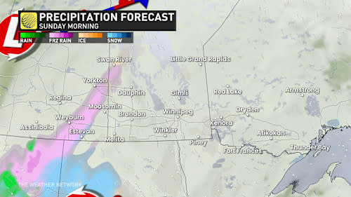

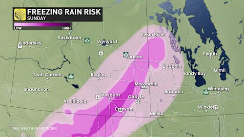
The freezing rain will begin Sunday morning in southeastern Saskatchewan, impacting Regina and Weyburn, and pushing into parts of western Manitoba. Areas east of Regina could see 5-8 hours of freezing rain potential east of Regina.
While just a couple of mm of freezing rain is expected, it is still enough to cause slippery driving and walking conditions across the region.

RELATED: Want a white Christmas? These Canadian cities have the best odds
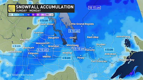
The snow will then begin developing on Sunday afternoon in eastern Saskatchewan, which will then reach across and envelop southern Manitoba by Sunday night, impacting Winnipeg with 5-10cm for the duration.
Snow will continue on Monday for parts of southern Manitoba. The system will also begin impacting northwestern Ontario throughout the day, dropping 5 cm on Kenora and Dryden.

Manitoba is also expected to see wind gusts up to 60 km/h, potentially impacting visibility along with the falling flurries.
Looking ahead, temperatures will dip back down again across the eastern Prairies and northwestern Ontario with low risk of continued snowfall throughout the rest of the week.
Stay tuned to The Weather Network for more forecast updates across the Prairies and northwestern Ontario.
